You can contact us with the problem you are having and we will investigate.
Stripe Online Payments
Sellingantiques have now partnered with Stripe card processing to give you a seamless purchase experience of antiques on sellingantiques.
Millions of companies of all sizes use Stripe online to accept payments and is the worlds No.1 payment gateway.
So how does it work: Look for the button in the antique details page to instantly purchase antiques from dealers who have activated Stripe online payments.
You can now easily filter and show antiques that only have this option enabled.
Using this button notifies us immediately that you have purchased this item. Once you have made the payment we will instantly mark it as sold to ensure that no one else can buy it.
Discounts can also be made available.
We are always improving the purchase experience for both buyer and seller and more and more dealers are enabling this option each week.
You are here:HomeMiscellaneousAntique Maps (8)
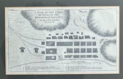
An antique map is a cartographic representation of geographic regions or areas that is considered old and holds historical, aesthetic, or collectible value due to its age, craftsmanship, design, or association with historical events, exploration, or cartographic advancements.Antique maps
... show more detail can come in various forms and formats, reflecting the cartographic techniques, artistic styles, and geographical knowledge of different historical periods. Here are some common types of antique maps:1. Pictorial Maps: Pictorial maps, also known as illustrated maps or bird's-eye view maps, are artistic representations of geographical areas that depict landscapes, landmarks, and prominent features in a stylized or exaggerated manner. They often incorporate illustrations, vignettes, or cultural references, offering a unique perspective and aesthetic appeal.2. Nautical Charts: Nautical charts are maps specifically designed for maritime navigation. They provide detailed information about coastlines, water depths, hazards, navigational aids, and other relevant data for safe navigation at sea. Antique nautical charts can include hand-drawn or engraved details, compass roses, and decorative embellishments.3. Celestial Maps: Celestial maps, also known as star charts or sky maps, depict the positions and movements of celestial objects such as stars, constellations, planets, and galaxies. They are used for astronomical observations, navigation, and astronomical education. Antique celestial maps often feature intricate depictions of constellations and celestial figures.4. Topographic Maps: Topographic maps represent the physical features of an area, including elevation, relief, rivers, forests, and other natural or man-made landmarks. They provide detailed information about the terrain and are used in various fields such as geography, geology, and land surveying. Antique topographic maps can showcase the cartographic techniques and surveying methods of their time.Antique maps are valued by collectors, historians, cartography enthusiasts, and those interested in exploring the history, geography, and cultural significance of different regions. They provide a tangible connection to the past, offering insights into the evolving understanding of the world and the artistry of mapmaking. Antique maps can be displayed as decorative pieces, used for educational purposes, or enjoyed for their historical and artistic value.On SellingAntiques, you can find a great choice of Antique Maps! We have 10 items for sale priced from £45 to £130 show less detail




 0
0




Thank you.
Your comment has been sent to Sellingantiques.